Hiking trail
Jebel Shams Plateau to Qarn Al Ghamaydah
 Curated with Muscat ShapersThe Muscat hub of the Global Shapers Community, a World Economic Forum youth initiative. They helped gather Oman's regions, attractions and trails.
Jebel Shams Plateau to Qarn Al Ghamaydah is a hiking trail in Al Hamra, Ad Dakhiliyah, Oman.
- Best season
- October to April
Distance
10 km
Elevation gain
400 m
Difficulty
●●●○○
Moderate
Scenery
★★★★☆
Key facts
TerrainOpen exposed summit plateau
Route formatOut-and-back
Fitness levelModerate
Experience levelSome hiking experience
Sun exposureHigh
Shade availabilityLittle to none
Water crossingsNo
PermitNo permit needed
Best seasonOctober to April
Best time of dayEarly morning
Mobile signalPatchy on route
ParkingInformal parking along the rim road
GuideRecommended
Family-friendlySuitable for fit families with older children
Beginner-friendlyNo
Access pointJebel Shams rim road / plateau
Emergency exit pointsRetrace to the rim road; vehicles reach the plateau edge.
Trail overview
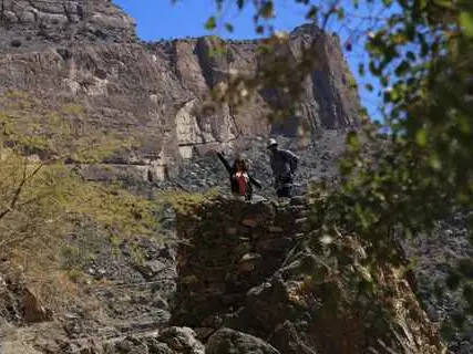
An open, exposed summit-plateau walk to the Qarn Al Ghamaydah high point, a quiet alternative to the crowded Balcony Walk with canyon-rim panoramas.
Key highlights
Crowd-free high plateau; big-sky views over the Grand Canyon.
Key risks
Exposure, no shade, easy to lose the line in cloud, cold at altitude.
Required gear
Hiking shoes, warm layer, navigation aid, 2-3 L water
Cultural considerations
Respect grazing land and any goat herders' shelters.
Environmental notes
Stay on established tracks; the plateau vegetation is sparse and slow to recover.
Tips from locals
Go on a clear day and carry a GPS track - the plateau line is easy to lose when cloud rolls in.